Littleton and Vicinity Weather Forecasts and Advisories
Below 6000 ft - Littleton, Englewood, Aurora, Highlands Ranch, Denver, etc..
Hazardous Weather Outlook | Area Forecast Discuss. (Technical)
Current Watches, Warnings and Advisories for North Douglas County Below 6000 Feet/Denver/West Adams and Arapahoe Counties/East Broomfield County (COZ040) Colorado Issued by the National Weather Service
|
||||||||||||||||||||
|
|
||||||||||||||||||||
|
|
|
||||||||||||||||||
|
|
||||||||||||||||||||
| Areas affected: Boulder And Jefferson Counties Below 6000 Feet, West Broomfield County; Central and East Adams and Arapahoe Counties; Elbert, Central and East Douglas Counties Above 6000 Feet; Jefferson and West Douglas Counties Above 6000 Feet, Gilpin, Clear Creek, Northeast Park Counties Below 9000 Feet; Larimer and Boulder Counties Between 6000 and 9000 Feet; North Douglas County Below 6000 Feet, Denver, West Adams and Arapahoe Counties, East Broomfield County | ||||||||||||||||||||
| Instructions: A winter weather advisory for snow means that periods of snow will cause primarily travel difficulties. Be prepared for snow covered roads and limited visibilities...and use caution while driving. Message summary: ...snow will continue in mountains today and spread onto front range and eastern plains tonight... ...winter weather advisory in effect from 6 pm this evening to 6 pm mdt friday... The national weather service in denver has issued a winter weather advisory for snow...which is in effect from 6 pm this evening to 6 pm mdt friday. * timing...snow will begin this afternoon over northern parts of the front range. Snow will spread south and become widespread this evening. Snow will decrease and end friday afternoon or early evening. Bands of heavy snow are expected tonight. * snow accumulations...3 to 6 inches. Up to 8 inches of snow will be possible in the foothills and where heavy snow lingers. * visibility...will be reduced to a quarter mile or less under the heavy snow. * impacts...snow covered roads are expected to make travel difficult tonight and friday. ...view the complete message |
||||||||||||||||||||
 Winter Weather Advisory - North Douglas County Below 6000 Feet/Denver/West Adams and Arapahoe Counties/East Broomfield County (Colorado)
Icon Legend: Icon key
Source: NWS Watches, Warnings or Advisories for zone COZ040
| National Weather Service Forecast for: Below 6000 ft - Littleton, Aurora, Englewood, Highlands Ranch, Denver, etc.. Littleton CO Issued by: National Weather Service Denver-Boulder, CO |
||||||||||||||||||
| Updated: 2:54 am MDT Mar 17, 2016 | ||||||||||||||||||
|
 Mostly Sunny
 Rain/Snow
 Snow Likely
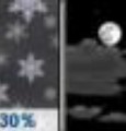 Chance Snow
 Sunny
Sunny Mostly Clear
 Sunny
Sunny Mostly Clear
 Mostly Sunny
| Today |
A 20 percent chance of rain after 4pm. Partly sunny, with a high near 49. South wind 5 to 13 mph becoming north in the afternoon. Winds could gust as high as 20 mph. |
| Tonight |
A chance of rain and snow before 8pm, then snow. Low around 20. North northeast wind 6 to 11 mph, with gusts as high as 17 mph. Chance of precipitation is 90%. New snow accumulation of 1 to 3 inches possible. |
| Friday |
Snow likely, mainly before noon. Cloudy, with a high near 32. North northeast wind 6 to 8 mph. Chance of precipitation is 70%. New snow accumulation of 1 to 3 inches possible. |
| Friday Night |
A 30 percent chance of snow, mainly before 9pm. Mostly cloudy, with a low around 16. North northeast wind around 6 mph becoming calm in the evening. New snow accumulation of less than a half inch possible. |
| Saturday |
Sunny, with a high near 42. Calm wind becoming east northeast around 6 mph in the afternoon. |
| Saturday Night |
Mostly clear, with a low around 25. |
| Sunday |
Sunny, with a high near 59. |
| Sunday Night |
Mostly clear, with a low around 36. |
| Monday |
Mostly sunny, with a high near 70. |
| Monday Night |
Partly cloudy, with a low around 42. |
| Tuesday |
Mostly sunny, with a high near 66. |
| Tuesday Night |
Partly cloudy, with a low around 37. |
| Wednesday |
A slight chance of rain. Partly sunny, with a high near 52. Breezy. |
Hazardous Weather Outlook & Latest Weather Warnings/Advisories
Dec 6, 2015 8:16 AM MST From the InterWARN Weather Center...There are currently no watches, warnings, or advisories in effect...Stay tuned to this web site for the latest weather information...
Station affiliations
|
Weather data published to:, |