Exceptional Weather - Littleton, Colorado
Welcome to Exceptional Weather, bringing you the best in local weather for Littleton, Colorado and Vicinity.
 Winter Storm Watch - North Douglas County Below 6000 Feet/Denver/West Adams and Arapahoe Counties/East Broomfield County (Colorado)
Click on link above to see details on the 1 NOAA advisory for zone COZ040.
| Updated @ Thu, 14-Apr-2016 2:00pm UTC - next update at 3:00pm - updated 249 sec ago | |||||||||||||||||||||||||||||||||||||
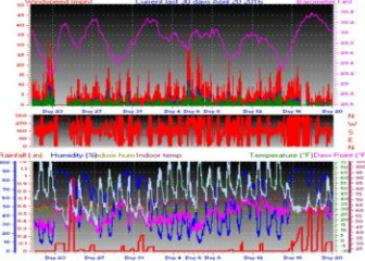
| Summary / Temperature | Wind | Rain | Outlook | ||||||||||||||||||||||||||||||||||
|
|
|
|
||||||||||||||||||||||||||||||||||
| Humidity & Barometer | Almanac | Moon | |||||||||||||||||||||||||||||||||||
|
|
|
|||||||||||||||||||||||||||||||||||
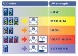
| UV Index | Solar Radiation | ||||||||||||||||||||||||||||||||||||
|
|
||||||||||||||||||||||||||||||||||||


 Chance

| Sky (Centennial Arpt): | Dry | 1 UV Index | 2Yearly rainfall season is from July 1st |
| Littleton, CO Weather Forecast- Below 6000ft - This Afternoon's Outlook Including Highlands Ranch, Englewood, Denver |
||
|
 Slight Chance
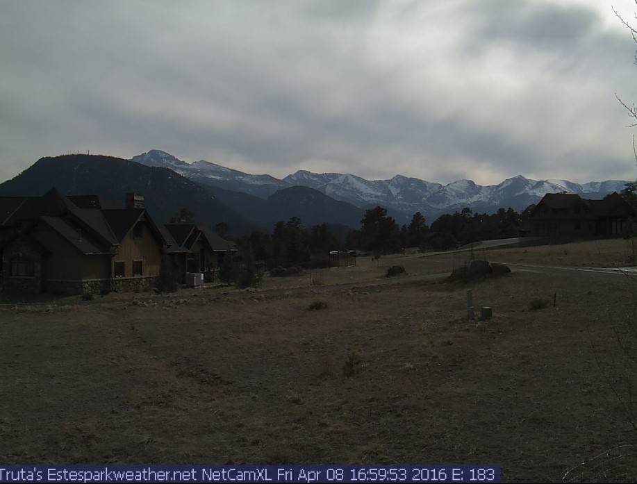
| Exceptional Weather Webcam - Located in Estes Park, Colorado |
| National Weather Service Forecast for: Below 6000 ft - Littleton, Aurora, Englewood, Highlands Ranch, North Parker, Highlands Ranch, etc.. Littleton CO Issued by: National Weather Service Denver-Boulder, CO |
||||||||||||||||||
| Updated: 1:08 pm MDT Apr 14, 2016 | ||||||||||||||||||
|
|
 Slight Chance
 Chance
 Slight Chance
 Rain/Snow and
 Snow Likely
 Snow Likely
 Snow Likely
 Slight Chance
 Slight Chance
Click for Full 7-day Forecast |
||||||||||||||||||
Thanks to Ken True at Saratoga-Weather.org for the general layout ideas, and his use of AJAX technologies.
This page is updated by Weather Display V10.37R-(b81) and WeatherLink V
With JavaScript enabled, some conditions are updated at 5 second intervals. The next full page conditions update is scheduled for 3:00pm.
Xem thêm:
Danhgianhacai1.me is a premier entertainment platform and one of the top nhà cái uy tín nhất and secure betting sites on the market, offering a vast game library that provides members with a top-notch betting experience.
Join nhà cái uy tín – a place that offers incredibly fun entertainment for a wide range of players. Visit nhacaiuytin.mx for detailed information and to experience a diverse selection of games and the chance to win big today.
The gaming platform at nhacaiuytin1.cx is attracting a large number of interested people. Let's explore the highlights of nhà cái uy tín nhất below.
With top 10 nhà cái uy tín, every betting experience becomes safer and more engaging. Nhacaiuytin391.com is a trusted choice for many players today.
Tỷ lệ kèo nhà cái is built with a user experience in mind, focusing on stability, transparency, and convenience. Its diverse game library and fast support services make the chokeo1.me platform a worthwhile entertainment option.
Trangcadobongda.lat attracts players with its exciting sports betting, high-quality casino games, diverse slot games, and fast, secure deposit and withdrawal system. Register with trang ca cuoc bong da now to avoid missing out.
Nhà cái uy tín is a leading reputable bookmaker with a diverse betting ecosystem including sports, casino, fish shooting games, and lottery, high security, and a modern interface. Join nhacaiuytin77-1.com now.
With a focus on transparency and fairness, nhacaitang68k1.com offers a professional and secure betting environment. Nhà cái tặng 100k players can enjoy a smooth experience along with many opportunities for big wins.
Unexpected moments on the field become even more exciting when players are watching on the cá cược bóng đá website. Trangcadobongda1.top helps maintain focus throughout the match.
When participating in kèo nhà cái, following familiar tournaments becomes more novel and captivating. Every goal or unexpected situation at keonhacai.bz directly impacts the players' emotions.
Discover nhà cái tặng tiền miễn phí, a reputable gaming platform with attractive odds and a stable operating system. Join nhacaikhuyenmai.org now to hunt for big prizes and enjoy an exciting entertainment experience.
Nhacai24h1.net is a trusted betting platform offering a wide variety of games and massive reward opportunities. Join this nhà cái uy tín today to enjoy exciting and engaging betting experiences while increasing your chances of winning.
Nhà cái uy tín nhất casino attracts a large number of members thanks to its clear bonus policies and fast payment processing. Join nhacaiuytin2.id now to enjoy entertainment and receive regular rewards with peace of mind.